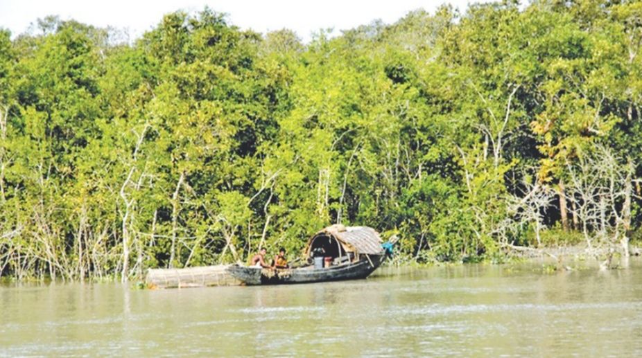
Although, in 2016, the National Green Tribunal held infiltration of population as a major cause for decay and degradation of the Sundarban, it can be averred that the phenomenon is nothing new and is an offshoot of the erroneous policy of ‘development’ that had been followed not just by the colonial British administration but by successive governments in independent India. In practice this ‘development’ meant massive destruction of forests and introduction of an unsustainable type of agrarian economy in an area which should have been left alone.
The enormity of the problem can be gauged from the fact that 54 low lying islands of the Sundarban now harbour more than 40 lakh people while the land available for cultivation is only 7,41,944 acres. They are mostly monocrop areas as the lands suffer from salinity due to proximity of the sea. As a result there is a natural hunger for more and more cultivable area leading to more and more destruction of forest cover and reckless exploitation of forest resources including unlawful poaching of the famous Royal Bengal Tiger which fetches substantial sums in national and international market.

Today the Sundarban encompasses a total area of 2.05 million hectares. But its majority portion lies within Bangladesh. The Indian portion, lying within the administrative jurisdiction of 24 Parganas(North) and 24 Parganas(South), has 0.79 million hectares bounded by the confluence of the Hooghly river in the West and that of the Meghna river of Bangladesh in the East. But due to massive denudation, the forest area has shrunk considerably.
In 1895 the Sundarban, including that area which now falls within Bangladesh, had a forest cover of 20,000 square kilometers. Around 40 per cent of it i.e. about 8000 square kilometers lay within what came to be called West Bengal in independent India. But in 1947 i.e. within a little over 50 years, the total forest cover of the Sundarban, consisting of both the Indian and the present day Bangladesh portions, came down to 10,000 square kilometers. The largest deltaic region in the world had been losing invaluable wealth of forestry at a breakneck speed.
For preserving the environmental balance in Sundarban it has to be understood first that the region is no more fit for human habitation which it used to be during the ancient and medieval period of Indian history. There is ample evidence of Sundarban’s prosperity in the Manasamangal of Bipradasa and the Ain-i-Akbari of Abul Fazl. But during the late medieval period the lower Gangetic basin had started shifting from the west to the east which resulted in severance of connections of many local rivers with the Ganges. The local rivers thus became mere brackish waters as they had neither any link with the mighty Padma, the principal eastward flow, and instead of sweet waters from the Ganges they became subjected to onrush of saline waters from the sea. This was the reason behind gradual obliteration of civilization from the Sundarban.
It can be said with a fair amount of certainty that during the middle of the 18th century dense forests of the Sundarban had extended beyond the present day Kolkata localities like Behala, Thakurpukur and Garia. Decayed stumps of Sundari trees which still abound in large numbers in the Sundarban were found in areas in and around metro railway stations like Jatin Das Park, Bhowanipore and Esplanade where excavations were done for the underground railway system.
But the colonial British administration was in need of more rice and other kinds of cereals for the gradually increasing European and native population of Calcutta. As a result denudation of the Sundarban forests started from 1770 to create rice fields, immigrant people were brought in who, by 1785, constituted a growing class of peasant proprietors.
There are many factors behind the present day decay and destruction of the Sundarban. But the primary factor is burgeoning of population from which all other factors have followed. At the earliest stage i.e. during the time of the British rule, the immigrants consisted of mostly people from the Midnapore district and tribals like Santals, Oraons and Mundas from the Chhotonagpur region. At a later date tribal identities got submerged and a completely new kind of population identity has developed here.
For understanding the scale of threat to the environmental balance in Sundarban we must be grateful to Anuradha Banerjee, a scholar of Geography who did her commendable research work at the Jawaharlal Nehru University. Her research points to a frightening trend of population settlement in the Sundarban region. The upper portion of the south 24 Parganas district- that forms parts of the stable delta of the Sundarban stretching from Thakurpukur in the West to Canning in the East and from Sonarpur in the North to Joynagar in the South- has small sized settlements compared to those lying in the areas beyond Joynagar which have been christened as the active delta by Banerjee. It is pertinent to note that for a vast area encompassing the western Hooghly side plains and the blocks of Baruipur, Mandir Bazar and Bhangar the average size of a village is less than 3 square kilometres.
As the area per village increases the location also changes towards the active delta spanning from the Sagar Island in the West to Basanti in the East. The high category of 9-12 square kilometers per village and the very high category of village groups encompassing more than 12 square kilometers are seen in areas in the extreme southern delta like Kakdwip and the Sagar Island.
The above figures indicate wanton destruction of forest cover nearer the core areas of the Sundarban. Now-a-days immigration has been taking place more at the active delta regions near the Bay of Bengal as villages here show a high concentration of 3000-4500 persons per village but with lower density figures than what are recorded in the areas further north near Kolkata. Greater village sizes with lower densities in the active delta can mean only one thing – more destruction of forests including the invaluable mangroves.
With increase of population and concomitant commercial activities mangroves are vanishing leaving the islands completely defenceless before nature’s onslaughts. Already there are reports that the Ghoramara island, situated just three miles away from the Bay of Bengal, is on its way to obliteration. But if the Sundarban , or a large part of it, is destroyed then Kolkata will not be safe also.
The writer is Associate Professor of History, Rishi Bankim Chandra College, Naihati.


